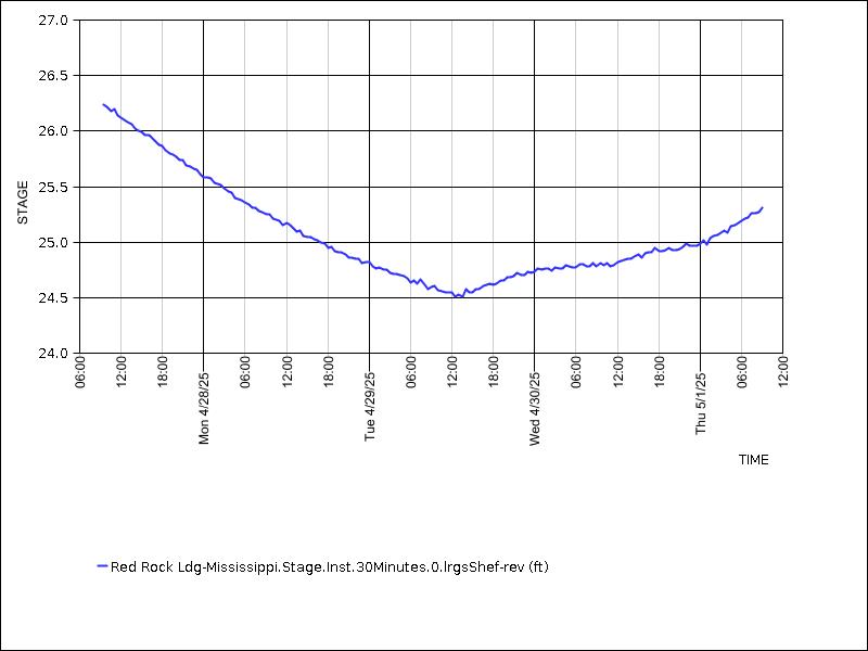
| DATE_TIME | VALUE |
| 07-14-2026 18:30 | 25.46 |
| 07-14-2026 18:00 | 25.46 |
| 07-14-2026 17:30 | 25.54 |
| 07-14-2026 17:00 | 25.53 |
| 07-14-2026 16:30 | 25.52 |
| 07-14-2026 16:00 | 25.55 |
| 07-14-2026 15:30 | 25.56 |
| 07-14-2026 15:00 | 25.56 |
| 07-14-2026 14:30 | 25.60 |
| 07-14-2026 14:00 | 25.62 |
| 07-14-2026 13:30 | 25.63 |
| 07-14-2026 13:00 | 25.66 |
| 07-14-2026 12:30 | 25.65 |
| 07-14-2026 12:00 | 25.69 |
| 07-14-2026 11:30 | 25.69 |
| 07-14-2026 11:00 | 25.67 |
| 07-14-2026 10:30 | 25.71 |
| 07-14-2026 10:00 | 25.72 |
| 07-14-2026 09:30 | 25.75 |
| 07-14-2026 09:00 | 25.73 |
| 07-14-2026 08:30 | 25.78 |
| 07-14-2026 08:00 | 25.80 |
| 07-14-2026 07:30 | 25.80 |
| 07-14-2026 07:00 | 25.82 |
| 07-14-2026 06:30 | 25.79 |
| 07-14-2026 06:00 | 25.83 |
| 07-14-2026 05:30 | 25.80 |
| 07-14-2026 05:00 | 25.85 |
| 07-14-2026 04:30 | 25.82 |
| 07-14-2026 04:00 | 25.85 |
| 07-14-2026 03:30 | 25.87 |
| 07-14-2026 03:00 | 25.88 |
| 07-14-2026 02:30 | 25.91 |
| 07-14-2026 02:00 | 25.91 |
| 07-14-2026 01:30 | 25.93 |
| 07-14-2026 01:00 | 25.92 |
| 07-14-2026 00:30 | 25.91 |
| 07-14-2026 00:00 | 25.93 |
| 07-13-2026 23:30 | 25.89 |
| 07-13-2026 23:00 | 25.95 |
| 07-13-2026 22:30 | 25.97 |
| 07-13-2026 22:00 | 25.99 |
| 07-13-2026 21:30 | 26.00 |
| 07-13-2026 21:00 | 25.99 |
| 07-13-2026 20:30 | 26.03 |
| 07-13-2026 20:00 | 26.02 |
| 07-13-2026 19:30 | 26.02 |
| 07-13-2026 19:00 | 26.05 |
| 07-13-2026 18:30 | 26.04 |
| 07-13-2026 18:00 | 26.05 |
| 07-13-2026 17:30 | 26.07 |
| 07-13-2026 17:00 | 26.09 |
| 07-13-2026 16:30 | 26.07 |
| 07-13-2026 16:00 | 26.10 |
| 07-13-2026 15:30 | 26.08 |
| 07-13-2026 15:00 | 26.12 |
| 07-13-2026 14:30 | 26.10 |
| 07-13-2026 14:00 | 26.14 |
| 07-13-2026 13:30 | 26.13 |
| 07-13-2026 13:00 | 26.13 |
| 07-13-2026 12:30 | 26.14 |
| 07-13-2026 12:00 | 26.13 |
| 07-13-2026 11:30 | 26.14 |
| 07-13-2026 11:00 | 26.15 |
| 07-13-2026 10:30 | 26.20 |
| 07-13-2026 10:00 | 26.18 |
| 07-13-2026 09:30 | 26.18 |
| 07-13-2026 09:00 | 26.18 |
| 07-13-2026 08:30 | 26.22 |
| 07-13-2026 08:00 | 26.24 |
| 07-13-2026 07:30 | 26.20 |
| 07-13-2026 07:00 | 26.21 |
| 07-13-2026 06:30 | 26.23 |
| 07-13-2026 06:00 | 26.21 |
| 07-13-2026 05:30 | 26.23 |
| 07-13-2026 05:00 | 26.23 |
| 07-13-2026 04:30 | 26.24 |
| 07-13-2026 04:00 | 26.27 |
| 07-13-2026 03:30 | 26.27 |
| 07-13-2026 03:00 | 26.28 |
| 07-13-2026 02:30 | 26.27 |
| 07-13-2026 02:00 | 26.30 |
| 07-13-2026 01:30 | 26.31 |
| 07-13-2026 01:00 | 26.30 |
| 07-13-2026 00:30 | 26.30 |
| 07-13-2026 00:00 | 26.22 |
| 07-12-2026 23:30 | 26.35 |
| 07-12-2026 23:00 | 26.35 |
| 07-12-2026 22:30 | 26.36 |
| 07-12-2026 22:00 | 26.39 |
| 07-12-2026 21:30 | 26.40 |
| 07-12-2026 21:00 | 26.37 |
| 07-12-2026 20:30 | 26.39 |
| 07-12-2026 20:00 | 26.39 |
| 07-12-2026 19:30 | 26.38 |
| 07-12-2026 19:00 | 26.41 |
| 07-12-2026 18:30 | 26.44 |
| 07-12-2026 18:00 | 26.44 |
| 07-12-2026 17:30 | 26.45 |
| 07-12-2026 17:00 | 26.46 |
| 07-12-2026 16:30 | 26.46 |
| 07-12-2026 16:00 | 26.46 |
| 07-12-2026 15:30 | 26.48 |
| 07-12-2026 15:00 | 26.48 |
| 07-12-2026 14:30 | 26.49 |
| 07-12-2026 14:00 | 26.52 |
| 07-12-2026 13:30 | 26.54 |
| 07-12-2026 13:00 | 26.54 |
| 07-12-2026 12:30 | 26.54 |
| 07-12-2026 12:00 | 26.54 |
| 07-12-2026 11:30 | 26.56 |
| 07-12-2026 11:00 | 26.57 |
| 07-12-2026 10:30 | 26.61 |
| 07-12-2026 10:00 | 26.62 |
| 07-12-2026 09:30 | 26.66 |
| 07-12-2026 09:00 | 26.64 |
| 07-12-2026 08:30 | 26.66 |
| 07-12-2026 08:00 | 26.68 |
| 07-12-2026 07:30 | 26.69 |
| 07-12-2026 07:00 | 26.67 |
| 07-12-2026 06:30 | 26.71 |
| 07-12-2026 06:00 | 26.71 |
| 07-12-2026 05:30 | 26.74 |
| 07-12-2026 05:00 | 26.74 |
| 07-12-2026 04:30 | 26.74 |
| 07-12-2026 04:00 | 26.76 |
| 07-12-2026 03:30 | 26.77 |
| 07-12-2026 03:00 | 26.77 |
| 07-12-2026 02:30 | 26.81 |
| 07-12-2026 02:00 | 26.83 |
| 07-12-2026 01:30 | 26.79 |
| 07-12-2026 01:00 | 26.82 |
| 07-12-2026 00:30 | 26.84 |
| 07-12-2026 00:00 | 26.84 |
| 07-11-2026 23:30 | 26.86 |
| 07-11-2026 23:00 | 26.87 |
| 07-11-2026 22:30 | 26.85 |
| 07-11-2026 22:00 | 26.88 |
| 07-11-2026 21:30 | 26.88 |
| 07-11-2026 21:00 | 26.90 |
| 07-11-2026 20:30 | 26.90 |
| 07-11-2026 20:00 | 26.88 |
| 07-11-2026 19:30 | 26.91 |
| 07-11-2026 19:00 | 26.88 |
| 07-11-2026 18:30 | 26.89 |
| 07-11-2026 18:00 | 26.87 |
| 07-11-2026 17:30 | 26.88 |
| 07-11-2026 17:00 | 26.88 |
| 07-11-2026 16:30 | 26.88 |
| 07-11-2026 16:00 | 26.89 |
| 07-11-2026 15:30 | 26.86 |
| 07-11-2026 15:00 | 26.89 |
| 07-11-2026 14:30 | 26.86 |
| 07-11-2026 14:00 | 26.86 |
| 07-11-2026 13:30 | 26.81 |
| 07-11-2026 13:00 | 26.78 |
| 07-11-2026 12:30 | 26.78 |
| 07-11-2026 12:00 | 26.73 |
| 07-11-2026 11:30 | 26.72 |
| 07-11-2026 11:00 | 26.67 |
| 07-11-2026 10:30 | 26.64 |
| 07-11-2026 10:00 | 26.60 |
| 07-11-2026 09:30 | 26.54 |
| 07-11-2026 09:00 | 26.53 |
| 07-11-2026 08:30 | 26.48 |
| 07-11-2026 08:00 | 26.41 |
| 07-11-2026 07:30 | 26.39 |
| 07-11-2026 07:00 | 26.34 |
| 07-11-2026 06:30 | 26.29 |
| 07-11-2026 06:00 | 26.19 |
| 07-11-2026 05:30 | 26.12 |
| 07-11-2026 05:00 | 26.05 |
| 07-11-2026 04:30 | 25.93 |
| 07-11-2026 04:00 | 25.84 |
| 07-11-2026 03:30 | 25.66 |
| 07-11-2026 03:00 | 25.54 |
| 07-11-2026 02:30 | 25.40 |
| 07-11-2026 02:00 | 25.25 |
| 07-11-2026 01:30 | 25.13 |
| 07-11-2026 01:00 | 25.04 |
| 07-11-2026 00:30 | 24.95 |
| 07-11-2026 00:00 | 24.82 |
| 07-10-2026 23:30 | 24.81 |
| 07-10-2026 23:00 | 24.68 |
| 07-10-2026 22:30 | 24.65 |
| 07-10-2026 22:00 | 24.60 |
| 07-10-2026 21:30 | 24.62 |
| 07-10-2026 21:00 | 24.60 |
| 07-10-2026 20:30 | 24.56 |
| 07-10-2026 20:00 | 24.55 |
| 07-10-2026 19:30 | 24.57 |
| 07-10-2026 19:00 | 24.54 |
- NOTICE: All data contained herein is preliminary in nature and therefore subject to change. The data is for general information purposes ONLY and SHALL NOT be used in technical applications such as, but not limited to, studies or designs. All critical data should be obtained from and verified by the United States Army Corps of Engineers. The United States Government assumes no liability for the completeness or accuracy of the data contained herein and any use of such data inconsistent with this disclaimer shall be solely at the risk of the user.