|
Water Management Data
- - River and Reservoir Reports
- - River Gage Data, Current Condition
- - Lock & Dam Gate Report
- - Internal Operational Forecast
- - Internal Operational Forecast (28 Day)
- - Reservoir Water Quality Data
- - Gage Precipitation
- - Gage Precipitation Totals with MAP
- - Weather station
- - WC Management District Boundaries
-
Project Data Plots
-
Reservoir Forecast Plots
Weather Information
- - Weather Channel Weekly Planner
- - NWS - St. Louis (WFO)
-
Radar
-
Quantitative Precipitation Forecast (QPF)
Navigation Information
- - USACE Thebes and Grand Tower, IL Forecasts
- - USACE Navigation Status Report
- - River Industry Bulletin Board
-
Navigation Maps
-
Navigation Home
Flood Frequency Study Profiles
- - Flow/Stage Frequency Calculator
- - Flood Frequency Study Homepage
- - Flow Frequency Study Final Report (PDF)
Environmental Management Resources
Research and Study Results
- - Perception and Reality Concerning the 1993 Mississippi River Flood: An Engineers' Perspective
- - Protecting Society From Flood Damage: A Case Study from the 1993 Upper Mississippi River Flood
- - Environmental Pool Management on the Upper Mississippi River (PDF)
- - Thompson Bend Riparian Corridor Project
-
Kaskaskia River
Links of Interest
- - Technical Center of Expertise-Photogrammetric Mapping
- - US Army Corps of Engineers
- - National Oceanic Atmospheric Administration (NOAA)
-
US Geological Survey
-
Department of Conservation
Water Management
The St. Louis District is responsible for maintaining the waterways that flow through a large part of Eastern Missouri and Southwestern Illinois. Located within the District’s boundaries are 300 miles of the Mississippi River, including its four most southerly Lock and Dams and its confluences with the Missouri and Illinois Rivers. Also included are several tributary rivers, dozens of other small streams, and five multi-purpose reservoirs - Lake Shelbyville, Carlyle Lake, Rend Lake, Mark Twain Lake, and Lake Wappapello. These waterways must continually be monitored and regulated to facilitate a number of purposes. The mission of St. Louis District Office of Water Control is to perform these responsibilities..Water Data Management
Water Control Operations

Website Guide and Project Operation Information: Webguide.pdf
The Water Data arm of this Section oversees the continuous process of hydrologic data collection, analysis, computation, and preparation for the St. Louis District. Through the administration of its Corps Water Management System (CWMS) program, Water Data provides an effective means of data acquisition, storage, visualization, dissemination, and modeling in support of the daily Water Control activities for the District. In addition to being used to assist in daily decision making, the data collected is frequently used internally and externally for navigation studies, flood plain studies, and construction activities. This data is also provided to various Federal, state, and local agencies, private entities, and the general public. It is posted here at this website and frequently updated for your convenience.

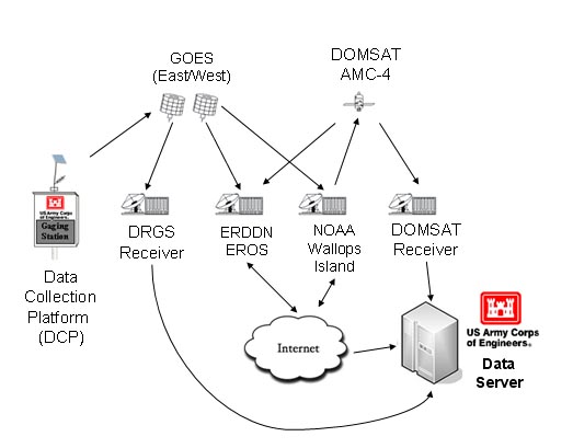
As a part of its data collection responsibility, Water Data is in charge of planning and implementing the District’s extensive network of hydrologic gauging stations. These stations consist of a technologically advanced combination of electronic and mechanical recording, reporting, and sampling equipment, providing Real Time readings to the District’s downtown St. Louis headquarters. Water Data maintains and operates approximately 155 of these gages on lakes and streams throughout the District. About 120 of said gages are automated using data-collection platform (DCP) and Geostationary Operational Environmental Satellite (GOES) technology (See DCS Figure). Gages throughout the district are owned and operated by the St. Louis District and maintained in conjunction with the U.S. Geological Survey and the NOAA/National Weather Service.
Water Control (WC) is primarily responsible for the day-to-day regulation of the four Mississippi River navigation structures and the five multi-purpose reservoirs located within the District. River flow is regulated to promote a number of interests, including flood control, navigation, hydroelectric power generation, water supply, erosion control, environmental enhancement, and recreation, in addition to others. WC must consider each of these interests with every important decision that is made. These decisions must then be coordinated with the project offices, Federal, state, and local government agencies, private water resources entities, and with customers. During high water events, such as those experienced during the summer of 2008, WC cooperates with MVS Emergency Operations in leading the flood fight efforts. Also, during low water events, WC cooperates with the River Industry Action Committee (RIAC) and the U.S. Coast Guard to ensure safe navigable waterways.


