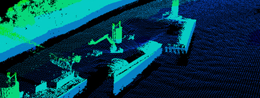
Data Collection
The Applied River Engineering Center teams with our Geospatial Engineering Branch to collect, post process, and analyze detailed multi-beam and single-beam bathymetric surveys, side scan sonar, vessel mounted LIDAR, water velocity vector (ADCP) surveys, and RTK water surface elevations. This critical data allows the river engineer to evaluate existing physical river conditions, and helps the engineer design quality channel improvement or restoration measures. In addition, if a model study is employed, the above data increases the reliability of model calibration.
Acoustic Doppler Current Profiler (ADCP)
An Acoustic Doppler Current Profiler, or an ADCP, is a hydro acoustic instrument that is used to measure the velocity of water within a given water column. The Doppler Effect, in principle, is used to calculate the measured shift in the frequency between the transmitted and received acoustic pulses of moving particles in flowing water. That measured shift can be translated to varying water velocities at different depths within a water column. ADCP technology can define in great detail the flow of water, including discharge measurements, velocity magnitude and direction, and suspended sediment. AREC uses ADCP mainly to study the effects of flow patterns, both magnitude and direction, in the navigation channel, around river engineering structures and side channels, at lock and dam structures, and at other boundary conditions were examination of the hydrodynamic flow response of the river is required.
The main external components of an ADCP are a transducer assembly and a pressure case. The transducer assembly consists of four transducers that operate at fixed ultrasonic frequency, typically 300, 600, or 1200 kilohertz (kHz). The transducers are horizontally spaced 90 degrees apart on the transducer assembly; all transducers have the same fixed angle from the vertical referred to as a "beam angle", that is typically 20 or 30 degrees. The transducer assembly may have a convex or concave configuration. The pressure case is attached to the transducer assembly and contains most of the electronics. It is required for the ADCP unit to be lowered into the water so that the sonic pings can be transmitted, received, recorded and analyzed. To prevent damage from occurring to the transducer and the pressure case unit while it is in the water, the assembly is protected from foreign debris strikes within a box cage. This cage is secured at the end of a moveable boom which allows the transducer assembly to be safely lowered into the water. The survey platform consists of a 19 foot twin engine vessel and a gas generator for supplemental power required for the operation of the computer, monitors and other electronic processing equipment.
The individual inputs that go to the processing computer include ADCP, GPS, depth sounder and pitch and roll sensor. The incoming ADCP survey data is processed by two main software programs which are HYPACK and WinRiver. HYPACK acts as the position liaison, relaying the location data to WinRiver. The position inputs include GPS (or RTK when available), depth sounder and pitch and roll sensor which are processed through HYPACK. Survey transects are also plotted within HYPACK. The individual transect survey lines are set up so that a measured amount of overlap occurs between passes to ensure complete coverage. ADCP requires the transects to be run across rather than with the current with a constant heading. WinRiver is the interface to the ADCP. This program displays ADCP measurement results, allows parameter adjustment and computes the discharge. This real-time discharge data collection program also processes the location inputs from HYPACK.
Bathymetry
Soundings that represents the submerged equivalence of an above-water topographic map. Bathymetric charts are designed to present an accurate and measurable description of the underwater terrain.

This bathymetry image consists color coded velocity vectors of St.Louis harbor
Side Scan Sonar
Side Scan Sonar is used for mapping the riverbed for many purposes, including detection and identification of underwater objects and various bathymetric features not normally detected with a multibeam system.

